Introduction Crammag Head is an area of mainly diorite rock (like rough granite). This area is south of Stranraer, on the east coast of the Rhins near the Mull of Galloway. This is probably the best and most pleasant of all the sea cliff areas in Galloway. Easy access, stunning scenery, friendly route approaches and great quality rock make for an enjoyable experience. It's also a good place to see porpoises, gannets and seals. Furthermore the area seems to be particularly prone to sunshine, and is as near to tropical rock climbing as you'll get in Scotland..! There is a short 15 minute approach down a farm track and over a couple of fields. Some of the crags are tidal, but many routes are still accessible at high tide and some are completely on dry land.
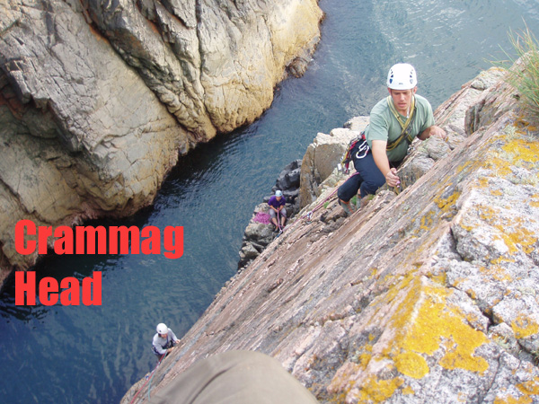
The header picture above shows Ian and Kate Brown on Firearms Certificate and Linda Biggar seconding "Wiped Biped" on the Pink Slab.
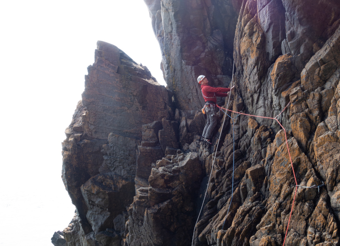
Myself on the first ascent of Nukka, Crammag Head, July 2023. A two-star Diff on great rock. This was a somewhat indirect version of Offin VD, which was first climbed earlier in the day. Photo courtesy of Stephen Reid @ Needlesports.
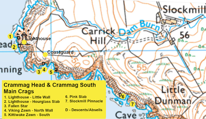
Access To get to Crammag follow the A77 or A75 towards Stranraer then the A716 down the east shore of the Rhins to Drummore village. From here follow the B7041 then an unnamed minor road westwards to Slockmill Farm. Relations with the local farmer are very good. The farmhouse is now a holiday rental, but parking is normally allowed in the farmyard, just be careful not to block any accesses and please be quiet, polite and considerate at all times. From here it is a 10-15 minute walk across fields to the various areas. The smaller outcrops at the north end of the cliffs lie directly under the obvious landmark of the lighthouse. The bigger crags are scattered from about 100m south of the lighthouse to nearly one kilometre south.
The Main areas at Crammag, from north to south are:-
Dangers Crammag is a sea cliff with generally good rock, but areas of dubious rock do exist on the bigger cliffs. Protection is not always easy to find on a few of the slabby routes; small gear, including microwires, and microcams are particularly useful. This is a very open stretch of coast so the crag will be hazardous in big seas or high winds.
Lighthouse Walls
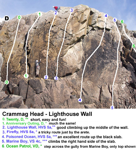
The most northerly area at Crammag is the "Lighthouse Walls". These are reached by following the concrete steps down from the lighthouse, then descending a gully over on the right The routes here are very short, but on good quality rock.
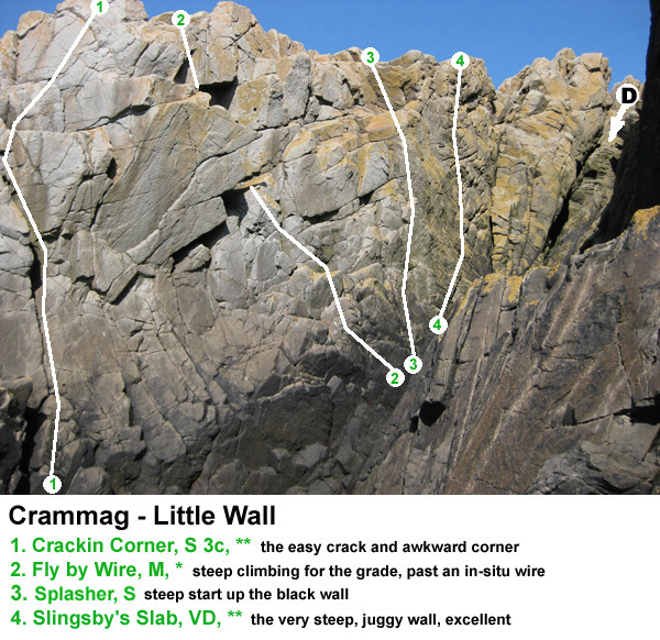
On the right hand side at the bottom of the descent gully (looking outwards) is a steep and uneven overhanging wall with a very prominent central flake. This is Little Wall. The routes here are spectacularly steep and easy, worthwhile even though they are a wee bit short. We climbed and named these a few years back, but most of these lines had probably been climbed before - as indicated by the in-situ rusty wire we found on the crux of the moderate! A couple of these routes will be hard to get to at the highest tides.
Left of the descent gully (looking out) are the original Lighthouse Walls, with some excellent short routes to 10-12m or so. there is a very handy system of ledges at the base. You can climb here in all but the highest tides, or biggest seas. Marine Boy was climbed and named by myself and Linda Biggar in August 1996, but it is described as Little Flasher, (with a first ascent in 1999) in the current SMC guidebook. It and Poisoned Ocean are probably the best of the routes here. For Ocean Patrol traverse across the southern gully (Mod) then climb the slab and rib beyond. Only Diff climbing but with few runners for the first 10m it deserves a VD grade. It can also be started from the left hand end of The Bit In Between. This gives a less good, but easier and better protected route.
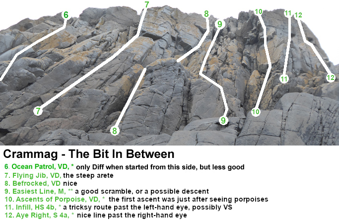
Between Ocean Patrol and Hourglass Slab, is The Bit In Between. There is a lot of good quality Mod and Diff scrambling and climbing here but the lines are not always obvious. I was involved in quite a few of the first recorded ascents here. This bit can be accessed from either the north below Lighthouse Wall at low tide, or from the south by Hourglass Slab at all but the highest tides. There are dry ledges beneath all the routes.
About 30m further south from the Lighthouse Walls is a beautiful pink slab - Hourglass Slab. Reach this by a longish scramble down the slabs on the south side (follows near the lightning conductor, mildly exposed, about Easy/Mod in climbing grades). This area is non-tidal and is therefore accessible in all but the biggest seas. This slab is due west of the lighthouse (not South as in the guidebook). If climbing several routes it will be quicker to abseil in to this area. The routes here are only 10-15m long, but on excellent rock....
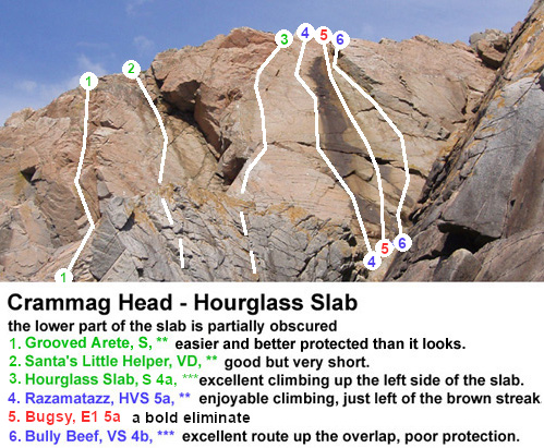
Hourglass Slab is bold for the grade. Between routes 1 and 2 is an easy Severe variation through the overlap and there is also an easier Severe finish to Bully Beef up and rightwards. Also to the left of the routes on this diagram (about 10 or 20m left) is a groove, with broken blocks further up, bordered by a blocky rib on the right - both these routes are easier than they look at about Diff. The groove in particular is an excellent climb.
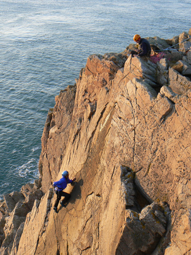
Sally Bennett on the crux moves of the very pleasant Razamatazz, HVS 5a, Crammag Head, Mull of Galloway. Warm rock and great light in February. Picture courtesy of Stephen Reid at Needlesports.
Gabarunning to Viking Zawn
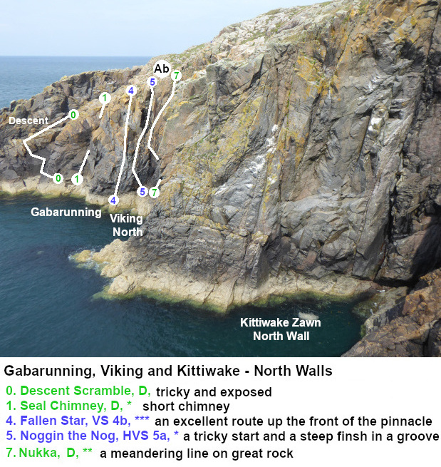
This area lies south of the old coastguard lookout, which itself is about 100m south of the lighthouse. The first climbs are immediately to the east (or southeast) of the long narrow (S-N) inlet of Gabarunning, which is marked on the 1:25,000 OS map. They can be reached by traversing in from Gabarunning at low tide, but this is quite tricky, (about Diff) and exposed in places. Start by climbing down a short steep wall and stepping over onto a big promontory. go down the slab on the east side of this promontory and then bridge across an exposed slot to get round a corner. Marked on the Kittiwake Zawn topo below. Alternatively abseil down the chimney of "Pillage" off a large block. The chimney finishes immediately west of the Fallen Star pinnacle, just 2m or so away.
Routes are generally 25-30m long, though Fallen Star may be better climbed as two pitches.
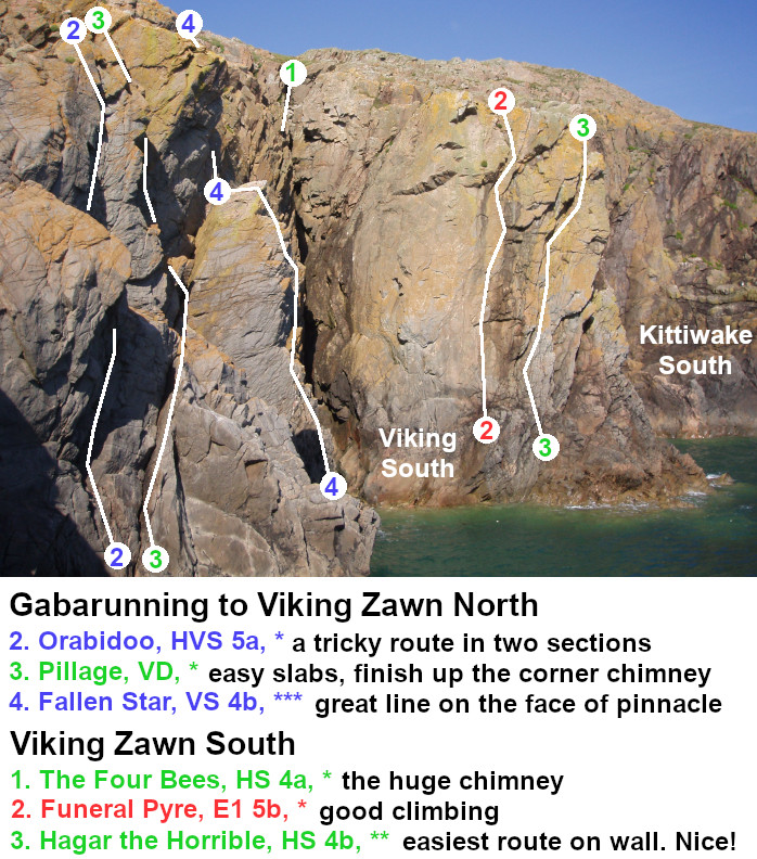
The north wall proper of Viking Zawn gets lots of sunshine in the mornings. Access is easiest by abseiling down the line of Offin (more or less) or the chimney of Hakon immediately right. This abseil is off a large block to a triangular area of broken ground below Hakon with many comfortable ledges and multiple belay options.
Routes are generally 20-25m long, though the big rising traverse of Northman is 35m.
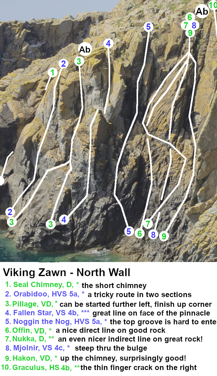
The chimney of Hakon is much better than it looks, usually climbable by traditional chimneying and without using any of the wet rock. Exit left onto the slab of Offin, or continue up a groove on the right. There are more routes further right which are had to photograph. See below.
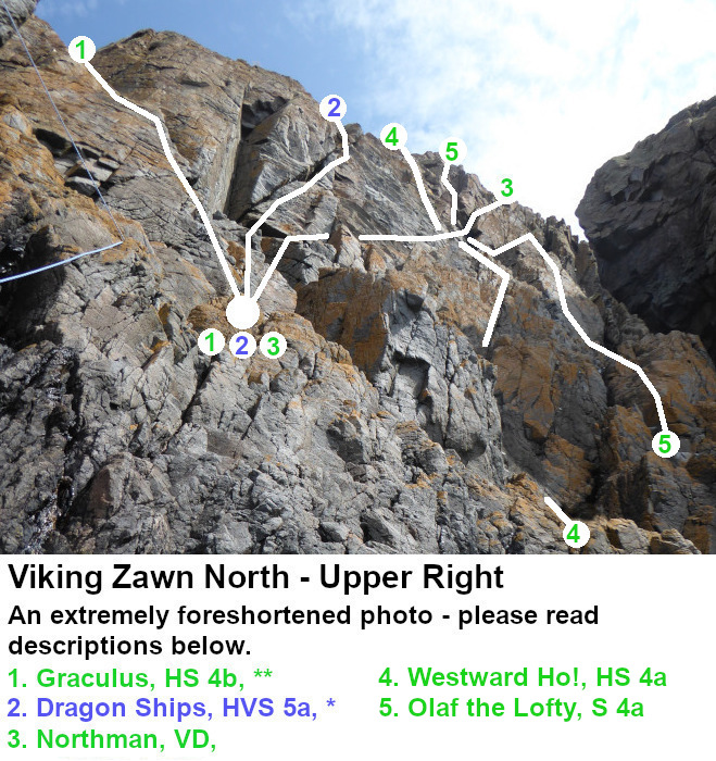
The first three routes are probably best started from the belay block at the foot (and slightly right) of the chimney of Hakon. Marked on the topo by a big white circle. The long rising traverse of Northman is 35m long. The other routes shown are just 20-25m. Graculus climbs the nice looking finger crack with plenty of protection. Dragon Ships is reported to be steep and strenuous. Northman takes the obvious rising ramp line with several awkward steps. Westward Ho! and Olaf take more direct lines up to cross Northman, then continue up the upper steeper rocks by either the left edge or the rock niche just right of the grotty looking slot.
The north wall of Kittiwake Zawn is very steep and has a number of fine climbs in the E-grades (or so I am informed!). See the topo above of Gabarunning, Viking and Kittiwake.
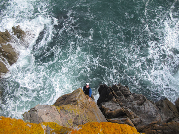
James Kinnaird pulling up steep jugs on the excellent pinnacle of Fallen Star. Picture courtesy of Stephen Reid at Needlesports.
For routes on the South Wall of Viking Zawn see the topo at the top of this section.
Kittiwake Zawn
There may be problems with seabirds in this general area some years. The walls are located 50m and 100m or so southeast of Viking Zawn. The north wall is very steep and reputedly has a number of good lines in the E grades. On the easier angled south side there is some good climbing in the easier grades. This area faces more or less due west so gets afternoon sun. The abseils are relatively straightforward to set up and the ledges at the base bigger than they look in this photo. Stingeroo and The White Stripes start from the same belay in a niche just above the high tide line behind the pinnacle (hidden in this photo). Abseil to them from a very large 10-tonne detached boulder
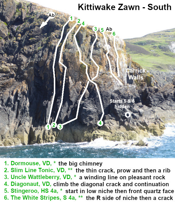
Carrick Walls
I've not climbed in this area and the crags are very hard to photograph form dry land... maybe one day soon!
Pink Slab
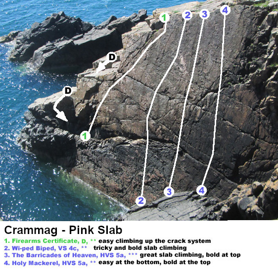
This crag and the Slockmill Pinnacle are about 15 minutes walk southwards on the coast from the lighthouse. The Pink Slab has some excellent but quite bold climbing on a big slab of compact diorite lying on the north side of a narrow inlet. The routes are about 15m long, a bit longer than described in the guidebook. To get here from the lighthouse head east over the hill of Crammag Head (called Carrick Hill) to reach a small inlet called Sloucheen Slunk, southeast of Crammag Hill. From the head of the inlet walk about 200m south parallel to the shore and you will be right on top of the slab, in fact you'll be right over the top if you shut your eyes. Access to the first two routes is by a fairly tricky (Moderate) scramble down towards the seaward end of the slab, then a traverse along a long narrow ledge about 2-3 metres above the high tide line. For routes 3 and 4 abseil to the sloping big grey ledge, this abseil approach also works for Wi-ped Biped.
Slockmill Pinnacle
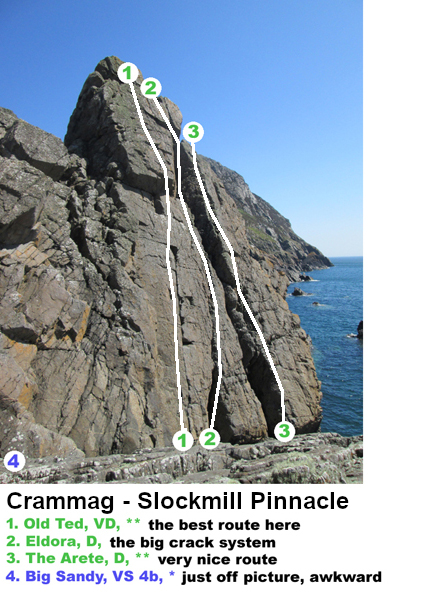
Just a hundred metres south of the Pink Slab is the Slockmill Pinnacle. The pinnacle itself is good quality greywacke, resting on a plinth of igneous diorite rock. There are a couple of good climbs on the pinnacle including an excellent V.Diff. up the west face. Access to these routes is easily by scrambling down from just to the north. The routes are a bit longer than listed in the guidebook, more like 16m. Descent by abseil off the pinnacle, usually is a sling in place.
Big Sandy lies just off the picture to the right. It climbs a diorite face passing a big black crystalline hold, then moving out right along an awkward crack, then back left and upwards. Not very well protected. Between Big Sandy and the pinnacle are a couple of easy (Mod.) scrambles.
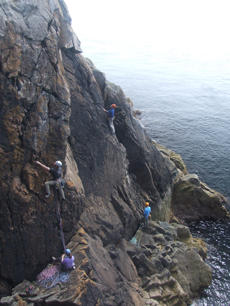
A busy Sunday on the Lighthouse Walls at Crammag Head, May 2013. Linda and Graeme are on Firefly HVS 5a *, and the other pair (from Glasgow) are on Marine Boy VS 4c ***.
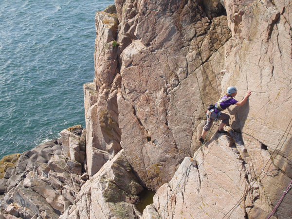
Kate Brown leading the very pleasant Hourglass Slab, S, on Hourglass Slab.
For information on tourist services in this area see the Mull of Galloway website.


